

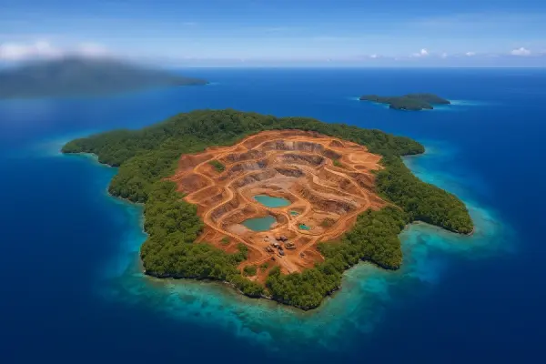
On June 9, 2025, social media users first reported that the satellite imagery of Gag Island, Raja Ampat Regency, had been blurred on Google Maps, making the land surface details indistinguishable. This small island, which is home to PT Gag Nickel's mining operations, previously showed a brown open area caused by land clearing for mining on Google Maps.
The Google Maps management team confirmed that blur requests can be submitted by property owners or authorities, and once approved, the blurring is permanent. Google emphasized that this procedure is designed to protect privacy and is not specifically intended to conceal mining activities.
Meanwhile, on the Bing Maps platform, satellite imagery of Gag Island remains unblurred. Tests using third-party mapping software reveal that Bing Maps still clearly shows the mining areas and road foundations, allowing direct observation of the cleared nickel mining land. This aligns with the recent Sentinel-2 imagery dated March 29, 2025, which also reveals the brown landscape resulting from the mining area clearance.
The Ministry of Environment and Forestry has conducted multiple field inspections from May 26 to May 31, 2025, discovering environmental damage due to sedimentation along the coastlines of Manuran and Kawe Islands. Although four mining operation permits outside Gag Island have been suspended, the operating permit for PT Gag Nickel remains active pending document verification and reclamation planning.
Activists from Greenpeace Indonesia argue that Google's blurring of the imagery could hinder public oversight of mining impacts and demand full transparency of field data. Conversely, the Governor of Southwest Papua and the Minister of Energy and Mineral Resources assert that the condition of Gag Island is not as severe as depicted in some viral social media videos and urge the public to rely on verified field data before drawing conclusions.


Responses